
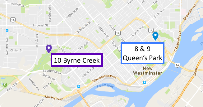
Queens Park, New Westminster Why Just Run
February 12th 2017 9:00am
Organizers: Alison Schoenhardt (Event Director), Ben Smith (Event Director), John Rance (Event Director), Scott Muma (Event Director)
Map: Queen's Park
IF YOU'VE SIGNED UP FOR SPRINT CAMP THERE'S NO NEED TO SIGN UP HERE ALSO - ONE OR THE OTHER PLEASE!
***PLEASE CHECK BACK BEFORE SUNDAY TO GET THE FINAL DETAILS ON TIMING, PARKING, LOGISTICS, ETC.... WE'RE EXPECTING AROUND 120 PEOPLE AND TIMING IS TIGHT, SO PLEASE INFORM YOURSELF****
This months Why Just Run race is part of Sprint Camp! Sign up for beginner, expert, or elite categories. Race against some of the best orienteers from the US and Canada! For expert and elite categories, you'll be treated to 2 short races: a set-up race and a chase/mass start! The top 25 or so from the set-up race will start in a head-to-head chase start for the second race! For those who don't make it into the chase start, we'll do a mass start for maximum fun!
The information below is taken from the Sprint Camp program. The Sunday events are number 8, 9, 10 for the weekend, hence the numbering! Given that we will have around 120 people there this weekend, please make sure you've read and understand the directions below, and consider either printing or bringing the directions on your smart device!
DRIVING DIRECTIONS TO QUEENS PARK
(Same place as Saturday’s Dinner please refer to those maps for detailed arrival images)
You MUST ENTER THE PARK OFF OF FIRST STREET ALONG THIRD AVE… Please :D
Take the Trans-Canada Hwy/BC-1 E. Take exit 33 towards Canada Way. Use any lane to turn right onto Kensington Ave. Use the left 2 lanes to turn left onto Canada Way. Continue onto 8th St. Turn left onto Eighth Ave. Turn right onto First St. Turn left onto Third Ave and into the park. Please Park between the arena and the baseball stadium.
QUEEN’S PARK INFO FOR SESSIONS 8 & 9
See “SESSION 8” & “SESSION 9” for Race Specific info. Ex) Start Times!
Map: 1:4000, 2.5m contours
Terrain: Varied urban park with playing fields, lawns, gardens, playgrounds, tennis courts, buildings, roads, paved and unpaved paths, etc. There is white forest and some dense thickets. The chase will use a residential area and a hospital as well as part of Queen’s Park. Expect generally fast running speeds.
Shoes: Use rubber soled shoes with aggressive tread. Metal spikes are not recommended
Out-Of-Bounds:The entire park except for the assembly/parking area is out of bounds prior to the start of the races. Pay particular attention to the olive green areas. Don’t cross them! If it looks like planting, go around. Do not cross the busy road except via the pedestrian overpass. Take care crossing all roads.
Map symbols: Brown X = rootstock or old, large stump. Open green circle = prominent tree. Green X = topped tree. Black X = bench, picnic table, or electrical box, etc. In a former graveyard, there are commemorative walls with headstones attached. These walls are mapped only if they are longer than 2 metres. Remember the ISSOM rule about distance between controls: similar features=30 metres, dissimilar features=15 metres. (there are lots of controls out there)
Misc: Low, easily crossed wooden fences are common but have NOT been mapped
Assembly Area: In front of the arena. Toilets are available in the arena. There is a small concession in the arena (coffee, hot chocolate, popcorn, nachos, hot dogs, etc).
Note: Minor hockey will be using the arena at the same time as us. We have been asked to take particular care not to block the doorways or congregate in the lobby.
SESSION 8 @ QUEEN’S PARK (SI-RACE 4)
By John Rance
Interval Start @ 9:00 -10:15
Courses: Point-to-Point. Optimum Route Elite 2.9km, 70m climb & Expert 1.85km, 35m climb
Control Descriptions: On map and available loose
Bring My Own Map Bag?: Yes!
SESSION 9 @ QUEEN’S PARK (SI-RACE 5)
By John Rance
Announcement of start times @ 11:05
Mass Start @ 11:15
Gathering time for those in the Chase @ 11:30
Chase Start @ 11:35
Courses:Point-to-Point. Optimum Route Elite 3.0km, 78m climb & Expert 2.1km, 58m climb
Control Descriptions: On map and available loose
Bring My Own Map Bag?: Yes!
For the CHASE: There are butterfly loops to discourage following. As well, descriptions will be printed on the map and loose descriptions will be lightly lightly taped to the back of the map.
AWARDS CEREMONY
The awards will be taking place at 12:15 by the Download Tent before the start of lunch so get comfy, grab a snack, and hopefully walk away with some cold hard cash.
QUEENS PARK to BYRNE CREEK
Follow Third Ave towards Sixth Street. Turn Right onto Sixth Street. Turn left onto Tenth Ave. Turn right onto Griffiths Drive. Turn left onto Southpoint Drive. Turn left onto Mission Ave. You should be able to find parking in the elementary school lot along Mission Ave. or along Southpoint Drive as you come down.
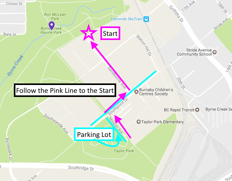
Please park where the Light Blue lines indicate and follow on foot the Pink lines to the Pink star which is the location of the Start!
SESSION 10 @ BYRNE CREEK (TRAINING)
By Brent Langbakk
Self Start @ 13:30-14:30
Timing: Self timed
Control Descriptions: On map
Bring My Own Map Bag?: Yes!
Terrain: Campus and forest paths
Shoes: Running shoes
Out-Of-Bounds: Marked on map
Assembly Area: North end of Sandborne Ave
Training Focus: Planning Ahead / Map Memory. One person relay with map exchanges!
