
Yaletown WET Wednesday Evening Training
March 20th 2024 6:00pm - 8:00pm

Organizers: Dawn Lessowai (Event Director), Victoria Cote (Event Director), Stan Woods (Controller), Robyn Astridge (Controller)
Map: Yaletown
It’s time to celebrate the coming of brighter evenings and the gorgeous landscape of Yaletown on a site that only 35 years ago was industrially polluted and just getting ready to host Expo ’86. This WET celebrates the foresight of city planners who designed the waterfront for all to use by installing green spaces, community centres and amazing transportation routes along, and in, the water that now allows for spawning herring and the occasional whale.
And thanks to Alton Ho for updating the map to the latest sprint standard!
Meeting location:
- David Lam dock (see pin below).
Courses:
Note: Downtown Vancouver streets are not set to North/South but rather at an angle.
Spring break is here for most school districts so this is a great time to bring your family out!
- Introductory Level: you can watch your young children from only 10 metres away as they use the map to find six flags on their own. An excellent place to practice your compass work for all beginners.
- Beginner East: this course will explore the East side of David Lam park and has two street crossings on streets with low traffic.
- Beginner West: this course is to the West of David Lam park and slightly more difficult than the East but after trying the East, you might be up for more of a challenge.
- Intermediate: this course travels across both East and West portions and allows for more route choice
- Intermediate complex: similar to the Intermediate course but more confusing for people wanting to practice compass and navigational skills before moving onto advanced maps.
- Advanced 1: approximately 3km long and technically challenging
- Advanced 2: another technically challenging course for the more advanced orienteers of similar distance to Advanced 1
Other important points:
- The park grass is lumpy and maybe unstable, wet and difficult to run on, but hopefully not leading to some sprained ankles...
- The official walking path is paired with a bike path so ALWAYS look for bikes before you cross!
- Lots of goose poo and even geese around so watch out for both!
Background:
Yaletown 35 years ago and now
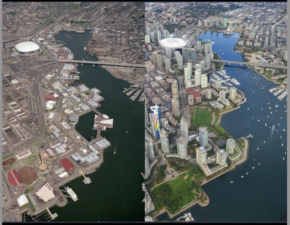
False Creek from Above (source: Changing Vancouver)
This recent Trish Jewison image is a perfect match to one taken in 1986. The earlier image must have been taken on the same flight that also took an image of Downtown South that we posted over three years ago. Although the contemporary shot was posted this year, we think it shows the city around September 2021. A more recent shot would see the new St Paul’s Hospital as a more substantial presence behind Citygate, at the end of False Creek, but in this image there appear to be piling rigs operating, creating the watertight tank that the new building is being constructed over. On the right, the tower crane is up for Tesoro, the last of Concert’s condo buildings, which has now been completed.
Some landmarks haven’t changed in 35 years. Science World is still there – although in 1986 it was the Expo Centre, one of the main attractions of the 1986 fair, showing a movie called A Freedom to Move in the OMNIMAX theatre. The only other remaining remnant of Expo 86 is the glazed BC Pavilion on the north side of False Creek. Its days are numbered, as a redevelopment has now been approved, and the casino that occupied the space for many years has moved into a dark tower that wraps around BC Place Stadium.
That has had a dramatic makeover. When it was completed in 1983 it had a fabric roof held up by air pressure, (the world’s largest at the time). In 2007 the Teflon Fibreglass roof tore after a snowstorm, and while it was patched up in time for the 2010 Winter Olympics, a long-term replacement was installed immediately after the games, with a series of massive steel columns supporting a retractible fabric roof under a web of cables with integral lighting.
In the years following Expo, most of the site was sold to one developer, Concord Pacific, who started development of the area in the late 1980s. They sold part to Henderson Development who started developing International Village (the cluster of towers above the stadium in these views), While Bosa developed Citygate, the row of towers at the end of the creek. Concord will have taken over 40 years to complete the entire project, which still has six infill developments built soon which will finally complete earlier phases, and the whole of North East False Creek, including a final waterside park. That will finally fill in the space between the stadium and Citygate. George Wainborn Park, at the bottom of the image, and David Lam Park, to its east (next to the red roof of the Roundhouse Community Centre) cover the most polluted parts of False Creek, that was once an area of heavy industry.
Image source: Trish Jewison in the Global BC traffic helicopter, published on twitter on 22 January 2024.