
McCartney Creek Why Just Run
May 12th 2013 9:30am
Organizer: Magnus Johansson (Event Director)
Map: McCartney Creek

Results:
Great to see so many happy faces after the epic bushwhacking courses in the pouring rain! Thanks to everyone who came out today and participated, plus all the help we got to set things up, tear down, flag the route to the start etc. Special mention to the brave souls who went out in the bush again to pickup flags: Jirka, Sergio and Scott. And of course, thanks to all mothers on mother's day!
As part of National Orienteering Week, come check out Vancouver's newest forest map! Bring your friends and family, there will be courses suitable for everyone. This is the first GVOC map created from laser scanned elevation data (so called LIDAR) and master mapper Bryan Chubb has just completed the field checking. You won't be happy if you miss this one!
Description:
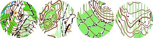
Typicall hilly west coast terrain with a dense trail network. Off trail running is often very slow, but there are pockets of open forests. The new map shows areas of slow running very accurately. Solid green shades indicate areas of slow running that also have poor visibility due to head high vegetation. The darkest solid green is often uncrossable brambles. The green hatching is indicating areas of slow running due to underbrush, but visibility is good.
Schedule:
9:30 am - Registration opens.
9:45 am - Introduction to Orienteering for Beginners
10 am to 11 am - Starts
1 pm - Course Closure, participants must report to the Finish by Course Closure Time.
Courses:
Four courses will be offered, Easy, Short, Expert and Elite. They are described on the right side of this page.
Please register by Friday May 10, so we can print enough maps.
Safety Precautions:
Courses mostly stay in the forest and trails, but if you do run on residential streets, please watch for cars.
Safety bearing is South.
Parking/Start/Finish Locations:
The finish and registration is in the forest, just east from the corner of Northlands Dr and Larkhall Cr (see map below).
Note: distance to the start is 1 km uphill on trails.
Parking is very restricted in this area so ONLY park on the East side of Northlands Drive, at the baseball fields of Larkhall or at the Ron Andrews Recreation Center (which is connected by a trail to McCartney Creek). We are absolutely FORBIDDEN from parking in any residential streets in the area and will lose our permit if this occurs. So please help us out by parking in the designated areas.
Washrooms by the baseball fields.
Acknowledgements:
Without volunteers, these events cannot take place. A hearty thanks to all those helping put this event on. If you would like to volunteer/help at upcoming WETs/WJRs or would like to organize a WET please let us know.
