
Cypress Falls East - DIY Forest-O Practise
May 29th 2022 1:00pm - June 19th 2022 8:00pm
Organizer: Laurent Mingo (Course Planner)
===============
This course has now been closed and controls moved to another location
===============
More Forest-O !! :
***** Update***** : 2 additional "runner's courses" added.
9 courses to choose from for a self-paced, self-served event to work on your forest O skills, and so until June 19th where a Social Meet will take place using some of the same courses.

***** LOST Honda Car Keys on 3.6km course **** : In case you found a set of car key (Honda) on the course, please send me a note. The keys may have been lost around control 6 - 13 - 14 on 3.6km course.
*****************************************************************
***** June 10th ****
: Start1_3600m pdf : MapRunF QR fixed.
*****************************************************************
***** June 16th **** : Control #39 was found on the ground and was replaced at the bottom of a tree. We will try to reset it.
*****************************************************************
Courses:
- length: from 0.7km to 3.6km, around 10% dist. as elevation climb on each (some a little more, some a little less)
- Difficulty: most courses are technical, and it is recommended to start with the short courses if you are not too familiar with forest navigation. Even the short ones can be challenging.
- Runner's O_1 Course (2.4km. 150m up) has most of its controls close to trails. It is an intermediate course.
**New Courses added**
- Runner's O_2 Course (5.1km. 350m up) has most of its controls close to trails. It is an intermediate course, physically challenging.
- Runner's O_3 Course (4.4km. 250m up) has most of its controls close to trails. It is an intermediate course. physically challenging
- On these you can only cross the creek at the designated spots (foot bridges). The rest of the creek and its banks (cliffs) are out of bounds. No controls are located close to the creek.
- Map files package:
- Naming convention example:
- Start1_700m.pdf : Course start on Start/Finish #1 and is 700m long
- Start2_1600m.pdf: Course start on Start/Finish #2 and is 1600m long
- a,b... suffix if 2 courses have same length and start point.
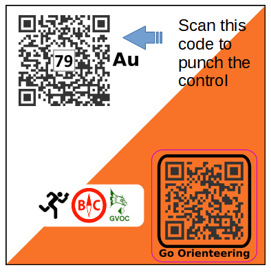
- PunchCard_SelfServeForestO.pdf: Punch/Record card, for each course, may be useful for small groups wanting to verify punched controls using the alphabetical code found on each control ie (#79, Au) on the example below. In this case you don't need a phone to scan the QR, just a pen.
- Naming convention example:
- Start/Finish 1: This link, located ~ 300m from parking area: S1
- Start/Finish 2: This link, located ~ 700m from parking area : S2
Maps can be obtained from the link found on the last registration page on 2mev (green button) .
Controls Plates :
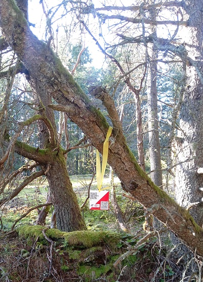
This is what you are looking for: a 10x10 cm O plate with yellow ribbon. Don't tug on the controls, the bio-degradable ribbon is not the strongest type. Most controls are placed on a tree next to the mapped feature.
Self-timing:
- Start1_3600m and Start2_2100m courses : MapRunF
- Other Courses:iOrienteering with QR scan with phone of controls, or use "punch" cards with a pen (in maps package obtained when you register)
- Setup QR codes are printed on the map sheets.
- For iOrienteering timing: scan the top left QR, the control number is also printed at the centre of the QR together with a letter code:
Registration:
The map package can be downloaded from a link provided on the last page of the registration through 2MEV.

Participant Look up: here
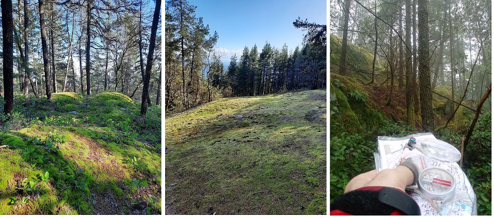
Let someone know where you are going and expected return time. The courses go through areas with:
- open rock slabs , moss covered, that can be quite slippery
- controls that may be near cliffs
- patch of forest that may require leg protection
Use your own judgment before proceeding through the course(s).
Parking: Either on Cypress Bowl road south of West Vancouver's Operation Centre, or on the Pop-up parking lot (gate close in evening, check time). It is not recommended to park along the Eagle Lk Access road as it is gated at the bottom.
Note: It is possible, albeit unlikely, that some controls go missing as the course is not checked on a regular basis. Let us know if some are (really) missing.