
Upper Lynn Valley Weekly Virtual Training
May 4th 2020 10:00am - May 10th 2020 11:00pm
Organizers: Laurent Mingo (Event Director), Robyn Rennie (Controller), Joanne Woods (Membership)
Map: Lynn Valley
3 challenging courses in an Urban-Forest mix this week:
These courses mix urban sections with small and large forest pockets. Be ready for roots, some mud if it rains and slippery sections of trails, (and off trail if you so desire). If you use the paper maps, the 1:10000 (or 1:7500) scale is unusual for a WET, so you will have to adjust to this as you move through the terrain and streets. If you only use the app on your phone and are able to zoom in, the original scale is still large, so the level of details is not as high as on a 1:5000 scale map.
Notes:
- there is a specific start/finish and parking for each course.
- distances are given as the crow flies. Wingless creatures should expect longer distances, add 20% for good measure. 20% more fun.
More Notes:
- many of the control points in the parks at the north of the map were hand drawn originally so aren't necessarily in the place the phone app is expecting them. They are obvious on the map so if you think you are in the right place you probably are
- be careful leaving #43 - it is easy to run off the map on the long course. The map on the phone will help you out of difficulty here.
Course 1: Long& Steep: 9km and 230m up (and down) scale 1:10000.
Like the course name said, it is long, with
significant elevation gain and loss. Big Fun.
Specific Comments about Long & Steep course:
Legs from 6 to 7 to 8:
Out of bound areas do not render on the phone app, so they are shown below with some additional information.
There is a large construction area preventing moving north from control 7. However, last week during field check there was a passage way along the yellow arrow to get you through. The first "impassable" fence has a large open gap in it, while the exit has a narrow gap by the fence that is passable, just go through this slowly if you decide to go through. Please give me feedback if this becomes not passable as the week goes.
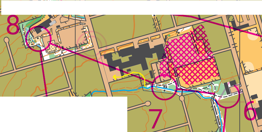
Leg from 9 to 10:
A possible route choice leaving control 9 is to remain in the forest along the creek. West of the lake in the centre of the image, sections of this trail can be slippery and are eroded in place. Please exercise caution in this section, especially if you run it shortly after significant rain.
Parking
for Long & Steep
: Just east of Eastview Elementary School, or in residential side streets.
Course 2: Shorter & Steep: 3.4 km and 170m up (and down) scale 1:7500.
The shorter course option for this week, still with
significant elevation gain and loss. Fun.
Specific Comments about Shorter & Steep course:
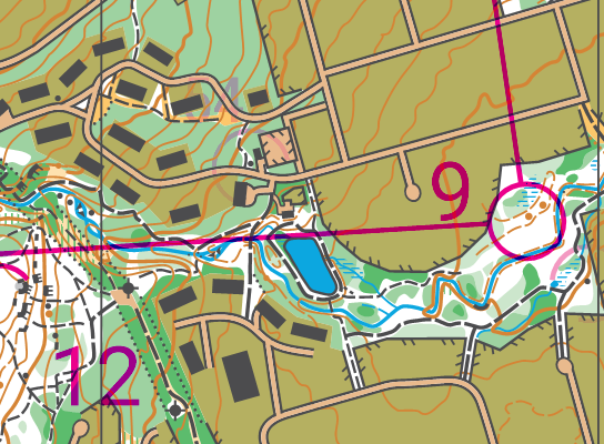
Leg from control 2 to 3:
A
possible route choice leaving control 2 is to remain in the forest
along the creek. West of the lake in the centre of the image,
sections of this trail can be slippery and are eroded in place.
Please exercise caution in this section, especially if you run it
shortly after significant rain.
Parking
for Shorter & Steep
: Lynn Valley Community Recreation Centre parking lot.
Course 3: Shorter & Less Steep: 4.8 km and 50m up (and down) scale 1:7500.
The course with the least elevation gain and loss. Still fun.
Parking
for Shorter & Less Steep
: East side of Kirkstone Skate park, or at Karen Magnussen community center, 100m west of Skate Park.
Maps (available starting on Saturday evening)
Because our insurance policy requires that everyone who participates in a GVOC event is a member of the club, please email gvoc.membership@gmail.com for a copy of the event map.
Remember that these events are to be run/walked individually obeying all the social distancing recommendations currently in place. However, for your personal safety p lease let somebody know where you are and what you are doing, especially because some of the forest sections are less busy than nearby urban areas . These are not sanctioned events; we don't retain any liability for participants. This is a do it at your own risk, training suggestion.
MapRunF
This event is available in MapRunF under “Select an Event > Canada >British Columbia > Vancouver > Wednesday Evening Training” – for instructions on setting up the phone app see here.
- The original scale being 1:10000 it is possible that some control location on the app end up a little off from the actual control.
- Remember, this is just a training suggestion, run smart and safe if you go .